
Design with Water
Rediscovering Public Spaces in Mexico City
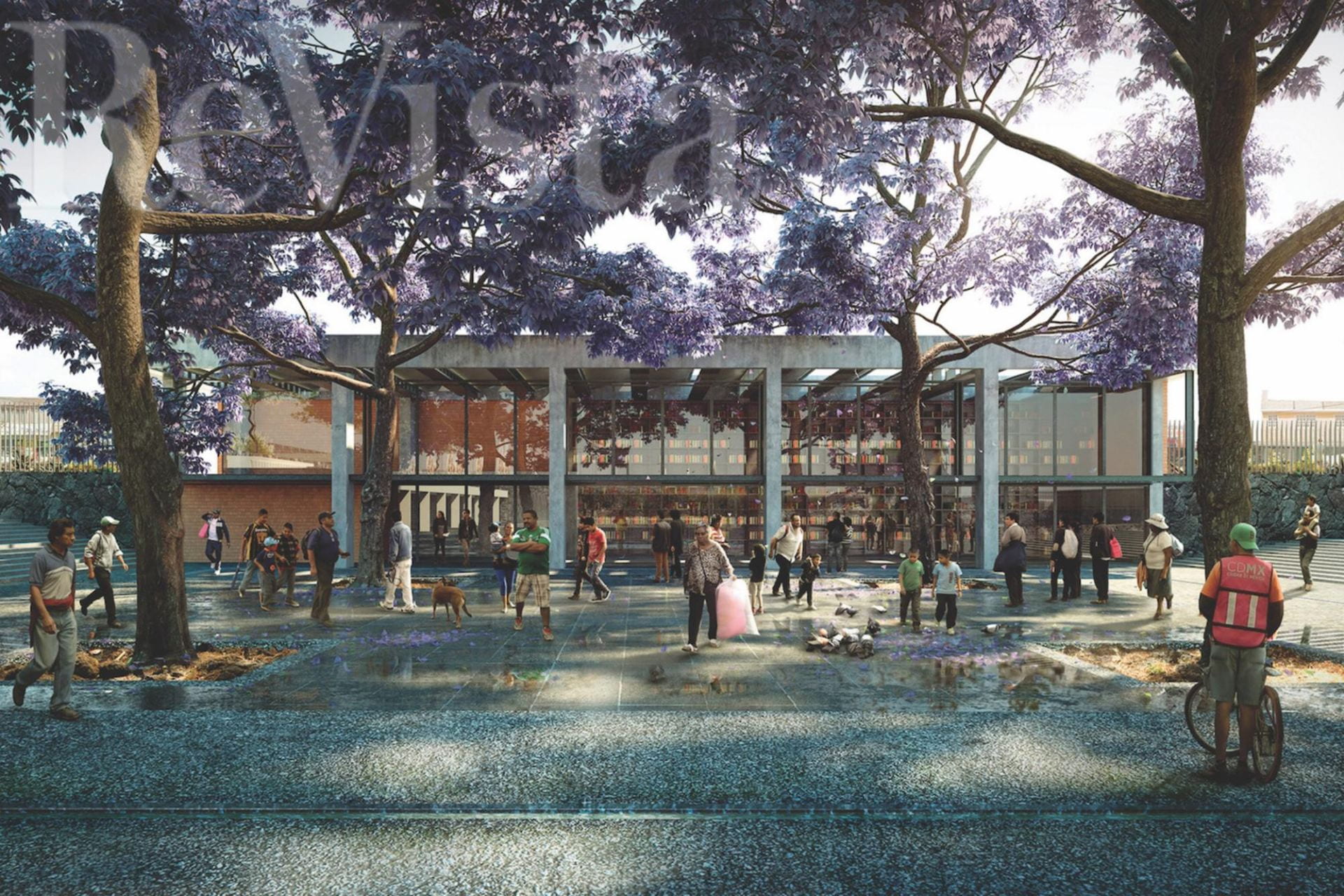
The purple jacaranda trees adorn public spaces.
Water is a key to the founding and shaping of cities. The first humans established settlements alongside bodies of water. Whether these populations flourished or not depended largely on smart water strategies. Whenever these failed, cities struggled to guarantee their future.
Mexico City is now a sprawling megalopolis of 22 million people. The city was an excellent example of landscape as infrastructure when it was founded at the center of a 425-square-mile system of lakes, and designed through a system of canals and chinampas. As the indigenous city evolved into a colonial one, the original waterscape turned into one of the largest, seemingly endless, and mostly dry urban fabrics. To cope with the results of colonial and subsequent urban development, monumental and sophisticated water management infrastructures have been constructed throughout the last five centuries.
These water management systems help the city survive, but they also have severe consequences: subsidence (the gradual caving in or sinking of an area of land), floods and overexploitation of the aquifer. These outcomes are provoking the collapse of infrastructure, meaning that one out of four Mexico City inhabitants do not have guaranteed access to a daily supply of water. In contemporary Mexico City, water has disappeared from the urban imagination. Its citizens have lost a necessary link with the liquid, one which guarantees the survival of the city.
Moreover, the drastic transformation of Mexico City’s natural context can be a decisive aspect to accelerate climate change. In the Basin of Mexico rainfall patterns have been modified as a result of warmer air holding more water vapor. We are now subject to shorter but more intense rain seasons, leading to an increased risk of flooding. At the same time, warmer air evaporates more quickly water from surfaces, drying out faster areas where it is not precipitating.
The city is subject to a paradox of scarcity of drinking water and excess of rain. It has repeatedly tried to break the unsatisfactory dialogue with the liquid, but the nature of the basin obliges it to constantly deal with this cycle. The relationship between the natural landscape, the form of the city, water and its citizens have spurred our research and projects.

THE HISTORY OF LANDSCAPE INFRASTRUCTURE IN MEXICO CITY
Mexico’s basin doesn’t drain anywhere. In more scientific terms, it’s endhorreic or closed, with no natural exit for its water. Thus, the system of lakes and swamps, nourished by the runoffs of the surrounding mountains, became the channel for water. Although humans first settled in the basin some 10,000 ago, the population significantly increased in the 12th century when the so-called seven Nahuatlacas tribes began to establish themselves on the shores of the lake system. They found excellent living conditions, securing the provision of water, fertile grounds and a temperate climate. Some of the towns founded by the different tribes, specifically those located in the southern areas around the Xochimilco and Chalco lakes, developed one of the most ancient, efficient and still practiced agricultural techniques: the chinampas.
The chinampasystem emerges from a deep understanding of the natural conditions of the Mexico basin. The changing water levels of the lake or more specifically, the five different wetlands that became a sole water body during the rainy season, provided a hint for how to harness them. Xochimilcans developed a strategy for constructing large-scale, thin and long woven baskets, filled with earth previously excavated from the shallow waters of the lake ground. With the aid of roots from the native ahuejote tree, the baskets became grounded to the water body. They were separated from one another by canals, providing transportation access around the area and good communication with the dry land. Along with a continuous exposure to a humid environment, the soil on the chinampa, mineralized through ancient volcanic activity, resulted in one of the most efficient and productive agriculture methods worldwide, having as much as five harvesting periods in the course of a year. This ancient agricultural method is undoubtedly one of the most sophisticated examples of landscape design. It was later expanded and turned into an urban design strategy in 1325 when Mexicas came to inhabit Lake Texcoco and founded Great Tenochtitlán (today’s Mexico City).
The chinampa system is definitely a landscape infrastructure, as it provided urbanized areas in the Basin of Mexico with a system to domesticate the ground, enjoy fertile agricultural lands, foster mobility and transportation, make use of a dynamic medium to negotiate with rising water levels, and devise a site-specific and sustainable strategy to deal with the context. It also meant a continuous exposure of the society to the basin’s natural conditions. Water was present always, sometimes flooding the city, but always an important part of the life of its inhabitants. Each of them knew the benefits and threats of water and was able to understand and learn the abilities to survive in this land.
WATERSCAPE TO DRY LAND
The Spanish conquest of Tenochtitlan led to a complete transformation of the city’s urban form. Through the Laws of the Indies, Spain was able to set a standard regarding regulations to establish or redesign cities in the New World. These were not site-specific and, in the case of Tenochtitlán, their application meant a strong clash with the natural conditions.
European Renaissance cities, planned through a grid of streets that connected a series of squares constructed with massive stone were difficult to implement in a waterscape. The original canal system that structured Tenochtitlan’s urban fabric was replaced by roads, displacing water with earth. This substitution meant that, when lake water rose during the rainy season, it would have no place to flow within the city, causing prejudicial floods. These happened often, forcing the new decision makers to implement an infrastructure strategy.
At the beginning of the 17th century, the city officials decided between two flood control projects. The first proposed the construction of enormous, dike-like infrastructure similar to those used by Aztec rulers to deal with rising levels of water by separating the city area from its adjacent lakes. The second proposal advocated the artificial opening of the basin by drilling a tunnel to drain the lake system on its northern end. The tunnel strategy was chosen and commissioned to Heinrich Mertens, a German engineer.
This choice of strategy defined how Mexico City would deal with its water supply during the following 400 years: drilling, piping and pumping the liquid both in and outside the basin. It also meant the disappearance of an intrinsic and essential element of historical use, which involved either digging or driving out the water: the new city decided to deny water.
Thus, in modern Mexico City water is no longer present. Of the 425-square-mile water network, fewer than twenty square miles remain. The decision to dry out the water network created empty, dry ground—ultimately soft and inappropriate, but nevertheless ideal to expand Mexico’s urban fabric. Mexico City’s urbanized ground runs for more than 965 square miles, occupying most of what was a lake. Thousands of deep wells have been dug in order to provide its inhabitants with water, causing disturbing ground subsidence. The city also occupies the permeable hillsides, blocking natural aquifer recharge, and making it hard to substitute the extracted liquid. Moreover, fast runoffs coming down the hills provoke huge volumes of the water to accumulate in the lower parts of the basin, making it impossible for any drainage system to hold and manage these amounts in the desired time. Four hundred years after a decisive action was taken to prevent floods in Mexico City, the city is still vulnerable.
REDISCOVERING THE PUBLIC SPACE AS A PARALLEL HYDRAULIC INFRASTRUCTURE
In 1960, the lake system was almost completely desiccated. The city created extensive infrastructure to import and export water—bringing it from the western adjacent basins, using it, and then sending it away to the east—and assure the city’s survival in terms of water access. However, the water is running out. The city is consuming the liquid from its neighbors’ basins, evoking a heated reaction from some municipalities. However, at the same time as it suffers from water shortages, the city is unable to manage the enormous amounts of rain and wastewater that inundate it during the storm season.
Several experts have urged decision-makers to implement a management system alongside the current one. The work we have been doing builds upon these efforts, but focuses the solution on grassroots acupunctural projects (hydrourban acupunctures). Our approach bets on hundreds of small-scale, disseminated interventions instead of large-scale infrastructure solutions. We focus on public spaces and their capability to serve both as soft decentralized infrastructure (meaning less dependent on energy, using the characteristics of the natural context to manage the liquid, such as absorption, retention, treatment through wetlands), as well as social-integration and recreational spaces.
In 2012 we started working for the borough of Iztapalapa, one of the areas most affected by scarcity and drainage of water. We asked the community to present small- scale alternative water management solutions in public spaces. We also demanded a budget of less than US$500,000.00. Surprisingly, we received more than 200 projects, from which an expert jury selected eight winners. Although these projects received awards, they were not implemented because the moment in which they were presented coincided with changes in government management. However, the contest demonstrated the community’s interest and understanding of diverse possibilities for managing water.
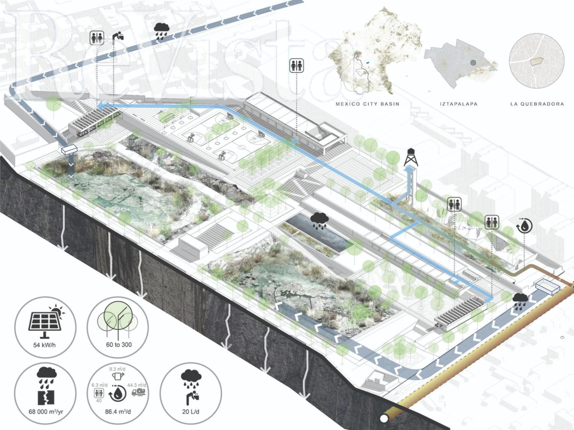
While working on the Iztapalapa project, we stumbled across La Quebradora, a site with ideal characteristics for the first hydrourban acupuncture project: permeable ground, property of the borough, and surrounded by a dense urban area lacking public spaces. The research team worked on a conceptual design proposal that, after years of hard work, was finally presented to the borough representative. In 2015, the project was accepted, and the borough hired a team coordinated by us from the National Autonomous University of Mexico (UNAM) to develop a complete study and construction plans for the Parque Hídrico Quebradora.
Parque Hídrico Quebradora introduces a contemporary waterscape that seeks to attack one of the city’s largest problems: water management. The idea is to reconfigure the hydraulic system by capturing intense water runoff and diverting it into an infiltration basin, thus reducing urban floods in the area. In addition, the venue treats wastewater through a joint water treatment plant and wetland system. This liquid will be used for the park’s hydric sustainability and redistribution in surrounding areas. Additionally, it harvests and filters rainwater that may be used for drinking. The park will be the first decentralized soft-water infrastructure in the city, setting a standard for any future urban design interventions, in which water management becomes seminal.
Along with its hydric functions, La Quebradora (to be inaugurated in September 2018) will host a ten-acre public space with cultural, sports and recreational programs. Structured through a grid of platforms, squares and pathways, the park will triplicate the original tree count and introduces only endemic vegetal species, typical of the volcanic stone context. Moreover, it will provide the surrounding population with a museum, a library, an open-air theatre, an outdoor gym, multi-use courts, children’s playgrounds and spaces to develop indoor activities. The park also will have public toilets, an important necessity in an area of the city where the population lacks a continuous water supply.
La Quebradora will serve an area of 28,000 inhabitants who lack recreational areas and regular access to water. The park’s open borders will emphasizing pedestrian mobility and aiming to reduce insecurity. It sets a paradigm for a new understanding of public space, where it will not only serve as an aesthetic venue but, more importantly, as an infrastructure managing the most precious resource in the city: water.
La Quebradora, currently under construction, is the first project in a more ambitious strategy, in which public spaces are intended to serve diverse purposes, ranging from decentralized infrastructures to water culture broadcasters. These thousands of sites spread throughout the urban fabric will become the medium through which water will return into the image of the city, not only as an aesthetic element, but more importantly, as a vital resource. Sometimes scarce, sometimes abundant, water will always be in need of an intelligent management through clear strategies provided by the form of the city and the awareness of its inhabitants.
Spring/Summer 2018, Volume XVII, Number 3
Manuel Perló Cohen is a Mexico City-based economist educated at UNAM and a city planner with a degree from UC-Berkeley. He is a tenured researcher at the Instituto de Investigaciones Sociales at UNAM and teaches graduate students in city planning, urban sociology and environmental policies. He combines his academic research with applied projects that can help change the urban water system in Mexico City.
Loreta Castro Reguera Mancera, MAUD 2010, is a Mexico City-based architect and urban designer. She teaches at the UNAM School of Architecture and has an architectural design studio: Taller Capital. She focuses on the design of public spaces capable of managing water through soft infrastructure. www.tallercapital.mx
Related Articles

Words that Matter
Those of us with little children often read The Lorax by Dr. Seuss to them at bedtime. The story points toward the past, because the Lorax is a ruin, with only residues remaining of something…
Prisoner of Pinochet: My Year in a Chilean Concentration Camp
English + Español
On September 11, 1973, at about eight o’clock in the morning, Sergio Bitar, one of Allende’s top economic advisers and the Minister of Mining, received a phone call from a colleague: the
One Long Night: A Global History of Concentration Camps
English + Español
In One Long Night: A Global History of Concentration Camps, Andrea Pitzer offers a thoughtful combination of investigative journalism and historical analysis that identifies the roots and
