A Review of Cave, City, and Eagle’s Nest: An Interpretive Journey through the Mapa de Cuauhtinchan No. 2
Rediscovering Mesoamerica

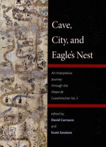
Cave, City, and Eagle’s Nest: An Interpretive Journey through the Mapa de Cuauhtinchan No. 2 Edited by Davíd Carrasco and Scott Sessions University of New Mexico Press, 2007
Cave, City, and Eagle’s Nest: An Interpretive Journey through the Mapa de Cuauhtinchan No. 2
Edited by Davíd Carrasco and Scott Sessions. University of New Mexico Press, 2007
The publication of Cave, City, and Eagle’s Nest is an exceptional achievement, bringing into the light a tremendously important but formerly obscure Mesoamerican codex or pictographic text. Analogies to the (re)discovery and interpretation of the Dead Sea Scrolls are not unwarranted insofar as the book marks the reemergence of a fabulous and fabulously significant 500-year old document—the Mapa de Cuauhtinchan No. 2 (or MC2)—which, aside from the attentions of a few specialists, had been previously unknown and inaccessible. The so-termed MC2 is an enormous map or single-page codex, nearly seven feet wide by three and half tall, which was painted on bark paper sometime in the mid-sixteenth century, that is, within a couple of decades of Fernando Cortés’ military conquest of the Aztecs in the 1520s but before the establishment of the mature colonial order in the 1580s. The MC2, though it depicts largely pre-Columbian events, emerges from and reflects an especially tumultuous era in early colonial Mexico.
Intricate in the extreme, the MC2 provides, in brief, a pictographic rendering of the migration-to-foundation history that led to the establishment of Cuauhtinchan, a village with deep pre-Columbian roots that continues to exist on the outskirts of the present-day Mexican city of Puebla. Though details concerning the precise identities and routes of the pre-Columbian protagonists are subject to great debate, we can be sure that the huge map charts a people’s story of origins and emergence from Chichimoztoc, the famed Place of Seven Caves, then their migration along a snaky path through the central Mexican landscape, past the much-revered sacred city of Cholula to their eventual destination at Cuauhtinchan. The myriad circumstances that transpired along this sinewy journey—political alliances and fractures, ecological discoveries and transitions, ritual sacrifices and petitions—are illustrated via more than 700 images and symbols, which are rendered with meticulous and minuscule detail, in many cases only a few centimeters high.
Thus, from a distance, the MC2 appears like a large illustrated roadmap, or perhaps even a pre-Columbian board game, complete with identifiable cultural and natural landmarks as well as trails of tiny footprints that record the paths and directions of travel, sure signs that what is recounted was a physical as well as mythological journey. Yet, in order to appreciate just what an eventful journey this was, one needs to look past the broad contours of the route from the caves of origin to Cuauhtinchan and zoom in for a closer look at any of the dozens of intensely detailed paintings that record episodes that presumably happened along the way. In other words, the MC2’s impressive unity of the composition—it truly is, among other things, a gorgeous work of art—is enhanced and redoubled by its innumerable tiny but masterfully expressive painted scenes of conflict, reunion, discovery and ritual celebration. Experts and novices alike could ponder the details of this document for hours on end, indeed for years, as they appreciate just how much is going on within its borders.
Following its original creation, the MC2 was guarded by the Cuauhtinchan community for generations, and then passed through numerous hands before coming into the possession of Angeles Espinosa Yglesias, who, in 2001, made it available for serious study through the David Rockefeller Center for Latin American Studies at Harvard University. Though the map’s existence had been well known for over a century, relatively little scholarly work had been done on it prior to this time. Answering the challenge to engage the newly available document from a wide range of different technical and interpretive angles, Davíd Carrasco, the Neil L. Rudenstine Professor of Divinity and Anthropology at Harvard, assembled an interdisciplinary team of some two dozen scholars representing the fields of history, art history, archaeoastronomy, ethnobotany, social anthropology, archaeology and the history of religions as well as specialists in restoration and conservation. A handful of this group had long experience in working with the MC2, but for most of the ensemble—which included scholars from Mexico, Guatemala, Puerto Rico, Holland, Great Britain and the United States—the subsequent set of working meetings provided their first opportunity to see the map.
Along with unprecedented historical and interpretive scrutiny, the three-year interdisciplinary project also provided the occasion for state-of-the-art digital restoration, which brought back into view faded colors and images lost in the creases and wrinkles of a document that had been unfolded and refolded literally for hundreds of years. Showcasing these restoration efforts, the 480-page book includes the insert of a one-third scale facsimile of the entire MC2 along with eighteen foldout pages that provide digitally enhanced photos of all sections of the map, each of which is supplemented with line drawings that clarify and reference specific features. Additionally, embedded within the text are more than 300 more photos and drawings of various elements of the MC2. These spectacular photographs alone would make a marvelous contribution to Latin American studies.
When that wealth of photographs is juxtaposed with 15 scholarly essays, one is left with a book that works on numerous levels and thus can appeal to many audiences. For some, the volume has the allure of grand coffee-table book. Every commentator lauds “the exceptional beauty” of the MC2, and the abundance of digitally enhanced close-ups provides a cornucopia of images that are at once quaint, quirky and profound, often whimsical if sometimes brutally violent. One can very easily imagine non-specialists, and even children, being fascinated by the many stories that could be told through this complex collage of pictures. For other general readers, the book brings the kind of “Indiana Jones appeal” of a two-tiered adventure story. At one level, the MC2 chronicles the trials, tribulations and triumphs of a people’s pre-Columbian journey; at another level, the volume also clues us as to the still-ongoing intrigue of a precious document that was variously hidden from Spaniards and then strategically showcased by the community, lost and then found, long-neglected and now restored. I, for one, find the history of the MC2 not less fascinating than the history in the MC2. Additionally, for more scholarly audiences interested in broad themes about space and time, pilgrimage and migration, indigenous acquiescence and resistance to colonial authority, the book offers an exceptionally rich case study. And for Mesoamerican specialists, the collected essays provide a wealth of fresh technical information and detail as well as a fabulous demonstration of what can happen when a group of scholars with very different disciplinary expertises all train their respective attentions on a single document. In this respect, the points of agreement between the various contributors are very interesting, but the occasional disagreements among them are even more provocative and revealing.
Each of the 15 chapters stands as an independent essay, and they could conceivably be read in any order. Nonetheless, the editors Carrasco and long-time collaborator Scott Sessions, following a very helpful introduction of their own, have arranged the essays into a logical three-part sequence. Part One, “Orientations in Time and Territory,” is composed of six essays that provide a range of responses to the overarching and inevitable questions about who, where, when and, most poignantly, to what end the map was created. We learn about the techniques, materials and colorants with which the MC2was originally painted (and maybe later touched up); and leading experts of the pictographic documents of central Mexico explain how the MC2 is, in some respects, a very typical origin-to-foundation narrative but in other ways is unique.
Nearly all of the authors in this first set of essays venture ideas with respect to the function of the map, ideas that reflect two sorts of tensions. They agree, for one, that the map most assuredly is a record of the past, an account of the origins of the people of Cuauhtinchan, which relates where they came from and the circumstances that eventuated in their present (mid-sixteenth-century) circumstances; but they note also that the creators of the map looked forward as well as back, crafting the migration story in a way that provided the community with an ongoing identity and worked to authorize a bright and privileged future for the lords of Cuauhtinchan. Furthermore, the authors concur that the MC2 was intended, at least in large part, for the consideration of people within the community, perhaps as a kind of pedagogical device designed to keep alive ancient traditions in the face of tremendous colonial-era social change and religious missionization. Most contributors also agree, however, that the MC2 was explicitly composed (or at least eventually utilized) to reach an external as well internal audience. Especially compelling is the prospect that the MC2, not unlike numerous other colonial-era indigenous documents, was designed first and foremost as a means of marshalling evidence in support of claims for disputed lands, that is, evidence that could be presented in Spanish courts. In short, though there is some healthy disagreement about the extent to which the map incorporates European as well as indigenous conventions, there is no question that the MC2 merges history and myth, and thereby interlaces cosmomagical concerns for the community’s proper relationship to the gods with politically expedient concerns about special entitlements to authority and to land.
The four essays of Part Two, “Narratives and Rituals of Roads and Roadsides,” get more specific by undertaking close readings of the activities and elements in numerous scenes that are depicted along the journey. At this point the benefits of the interdisciplinary assemblage of contributors are especially apparent. Specialists in iconography, for instance, compare the MC2 to other indigenous documents in order to identify most of the numerous deities in the map, and they comment on the diversity of skin colors, hairstyles, clothing types, hand gestures, etc. to venture identifications of the multiple ethnicities that play so large in the alliances, confrontations, victories and defeats that are recounted in the MC2. An archaeoastronomer relies on special knowledge of the eclipses and other celestial phenomena contemporaneous with the creation of the MC2 in order to unravel the map’s specific calendrical references and allusions. And ethnobotanists bring a distinct expertise that not only allows them to identify a stunning range of cacti, yucca, orchids, maize, cotton, marigolds, amaranth and trees that appear along the migration route, but also to appreciate the distinctive meanings and medicinal properties associated with each of those species.
Part Three, “Comparisons and Approximations,” is composed of five essays that offer more interpretatively venturesome and comparative readings of the map. Parallels to contemporary Maya practices suggest to one author that the MC2 may have been spoken, sung and ritually performed in the context of initiation ceremonies; a pair of specialists on North American Indians look to the mythic and pilgrimage traditions of that area in order to explore the possibility that Cuauhtinchan community members utilized the MC2 as means of imaginatively “reentering” the story of their ancestors. Another author capitalizes on analogies drawn from the colonial contexts of the Caribbean and Amazonian Basin; and another muses at the ways in which the MC2 has accrued rather than lost significances over time, and thus remains a highly salient document for contemporary audiences. A final essay by editors Carrasco and Sessions accentuates the unique role of urban centers in the creation and re-creation of human culture and identity as a means of both reaffirming and taking issue with interpretations in the earlier essays.
As director of the Moses Mesoamerican Archive at Harvard, Carrasco, himself a historian of religions and specialist on the Aztecs, has orchestrated numerous such collaborative projects over the past 25 years; while many of those collaborations have issued in highly significant publications, Cave, City, and Eagle’s Nest now becomes a serious contender for his greatest scholarly accomplishment. The wealth and diversity of viable interpretations leaves readers of this collection of essays with a provocative uncertainty, the sense of a mystery imperfectly resolved rather than an airtight case as to the use and status of the MC2. As Carrasco notes, this hugely impressive volume constitutes only one early step in the study and appreciation of the Mapa de Cuauhtinchan No. 2, an invaluable document that is certain to engender a raft of studies among future generations of scholars—but it is most certainly a large and auspicious first step. No one who searches out this book will be disappointed.
Lindsay Jones is a professor in the Department of Comparative Studies at Ohio State University.
Related Articles
Editor’s Letter: The Sixties
When I first started working on this ReVista issue on Colombia, I thought of dedicating it to the memory of someone who had died. Murdered newspaper editor Guillermo Cano had been my entrée into Colombia when I won an Inter American Press Association fellowship in 1977. Others—journalist Penny Lernoux and photographer Richard Cross—had also committed much of their lives to Colombia, although their untimely deaths were …
The True Impact of the Peace Corps: Returning from the Dominican Republic ’03-’05
I am an RPCV: a Returned Peace Corps Volunteer. For me the Peace Corps was an intense life experience, above anything else. As I continue to reflect on it, I am struck with the many and varied ways in which it continues to affect my life. As a PCV in the Dominican Republic from September 2003 to November 2005, I lived, worked, and learned in a small sugar cane-dependent community two hours outside of Santo Domingo…
In the Shadow of JFK: One Peace Corps Experience
I am often asked about the Peace Corps by students and recent graduates. The most frequent questions are, “why join?”, “what did you do?”, and “what has it meant for your career?” Here is my story. My earliest recollection of international curiosity was in the fourth grade when Sister Margaret Thomas described her experience as a recently returned missionary in Bangladesh. In high school, my sister Mary went to Peru on …


