Deploying Wireless Sensors for Volcano Monitoring
A Harvard Computer Scientist on Volcán Reventador, Ecuador
I’m knee-deep in mud, carrying forty pounds of equipment on my back, exhausted from a grueling hike – no, make that scramble – through the jungle to reach our deployment site. I’m doing all I can to keep up with the rest of the research team, not to mention a group of Ecuadorean porters who make it look easy to carry twice my load. (I’m thinking that specializing in computer science did not exactly prepare me for this.)
After three hours, the jungle suddenly disappears. I find myself staring at the naked branches of long-incinerated trees on the edge of a vast open clearing— a surreal landscape that seems to belong on barren Mars., Ahead of us looms the caldera of Volcán Reventador, one of several highly active volcanoes in Ecuador, about 56 miles from the capital, Quito. I can barely make out the cone of the volcano, shrouded in low clouds and mist.
This is where we will be installing sixteen wireless sensors to monitor the earthquakes and eruptions of the volcano. As we reach the upper flanks, the vent is clearly visible above us, a white fumerol rising out of its depths. There are no trees, no bushes, barely any vegetation; the volcano conveniently deforested the area in 2002 with an enormous eruption that closed down the Quito airport with its ashfall. We scout a few likely locations for our sensors, which we will install over the next three weeks. Then we set up camp for the night, exhausted.
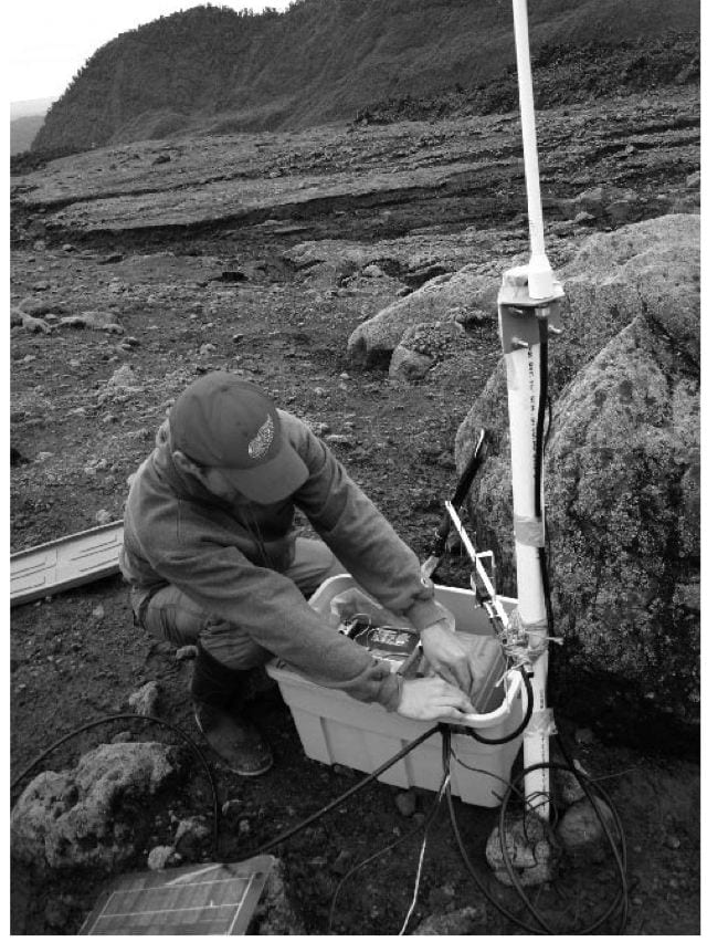
We are computer scientists from Harvard and seismologists from the University of North Carolina, the University of New Hampshire and the Ecuadorean government’s volcano monitoring agency, Instituto Geofísico. Our group has been working together for the last three years to develop a new kind of wireless, portable sensor for monitoring activity at volcanoes. Each sensor measures both seismic activity (ground motions caused by earthquakes within the volcano) and infrasound (low frequency acoustic signals, well below the range of human hearing). Collecting this data from an erupting volcano can assist geophysicists in understanding the physical processes occurring within the volcano. It can also help government agencies assess the volcano’s potential hazard level.
Two features make our sensors special. First, they have a low-power radio, allowing them to transmit and receive data via a wireless connection. Each node can relay data for the others, so we can string the sensors along in a line several miles long, allowing data to hop from sensor to sensor until it arrives a gateway radio that transmits data back to the volcano observatory. Second, each node is fairly small, fitting in a small case the size of a thick paperback book. This means that even out-of-shape computer scientists like myself can carry five or six sensors in a backpack, rapidly deploying them in remote locations like Reventador. This is an enormous improvement on current monitoring systems, which are bulky, heavy, and powered by multiple car batteries. Just imagine carrying a car battery, on your back, up the side of a muddy slope for four hours!
Our sensors are in fact small computers, powered by D-cell batteries, which we can program to detect interesting signals (such as the seismic signature of an eruption), record data to a local flash memory, and transmit the data over the radio. We can also use the wireless link to send commands back to each sensor to vary sampling parameters and to update its software. Signals are relayed back to the volcano observatory, which in this case was a small hotel several miles from the volcano itself. There we can visualize the data on a laptop to watch volcano activity unfold in real time. Other research groups are also exploring this new technology of wireless sensor networks in other application domains, including such diverse areas as monitoring animal habitats, microclimates in redwood forests, leaks in water pipelines and structural safety of bridges and buildings.
We deployed this sensor network at Reventador in August 2005, collecting data on hundreds of eruptions, earthquakes and tremors. As with all field work, the deployment was not without its challenges. At one point, a software bug caused all of the nodes to crash. One of my graduate students had to hike back to the volcano, with his laptop, to reprogram each sensor by hand. Fortunately, I was back in the United States by then. And, perhaps predictably, the volcano actually destroyed one of our sensors. A soccer-ball-sized rock ejected from the vent during one of the frequent eruptions managed to shear off the radio antenna mast. If you imagine hitting the flag from a 200-yard golf drive, you’ll realize how improbable this was.
Our group is continuing to develop larger and more intelligent sensor arrays for volcano monitoring, with the eventual goal to be able to pinpoint the source of an earthquake in real time or to display a 3D “movie” of the volcano’s interior as the data streams in from the sensors. We hope that wireless sensor networks will soon find their way into the hands of monitoring agencies that want to rapidly install large sensor networks on hazardous volcanoes. We do have our work cut out for us to make the technology reliable and easy to use, and more field deployments to test our ideas will be needed.
I guess that hike was not so bad after all.
Winter 2007, Volume VI, Number 2
Matt Welsh is an Assistant Professor of Computer Science at Harvard University.
Related Articles
Editor’s Letter: Natural Disasters
We were little black cats with white whiskers and long tails. One musical number from my one and only dance performance—in the fifth grade—has always stuck in my head. It was called “Hernando’s Hideaway,” a rhythm I was told was a tango from a faraway place called Argentina.
After the Earthquake: Juan’s Life
Juan was a construction helper. He lived in Armenia, but his parents were from the Antioquia region, who had fled because of the violence there. The mother of his children was called…
Political Memory
Late in 1717 Dr. Joseph Surin, precentor of the Cathedral of Old Guatemala, carried out some calculations: had the mudslide that wiped the city on the 28th of August, feast day of Saint…


