Natural Hazards
Keeping them from becoming natural disasters in Latin America

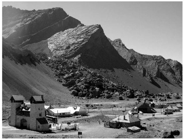
A 20th century landslide near Las Cuevas, Argentina on the road between Mendoza, Argentina, and Santiago de Chile. note bus in foreground for scale. photo by sue kay, Cornell University. Photo by Sue Kay
Natural disasters in the Americas are a paradox. The region has the dubious honor of boasting some of the largest natural hazards on the planet. Yet, the largest events are not always the most destructive, while much smaller events can be catastrophic. Two volcanic eruptions in South America illustrate this point. The 1991 eruption of Cerro Hudson volcano in southern Chile was perhaps the fifth largest of the 20th century, but resulted in no known human fatalities. At the other end of the continent, a small eruption (there are usually one or two this size or larger per year) at Nevado del Ruiz in Colombia in 1985 initiated mudflows that killed more than 23,000 people, making it the second deadliest volcanic eruption of the 20th century.
The paradox of large events causing little damage and small events creating major havoc illustrates the difference between natural hazards and natural disasters. Natural hazards are events with a potential to cause harm to human interests, while disasters indicate that human interests were in harm’s way and suffered serious destruction. Latin America has been fortunate that few human interests have been in the path of some of the largest natural hazards. Nevertheless, about one half a million people died in Latin America in the 20th century as a result of natural disasters. Civilization is incapable of stopping natural hazards, but steps can be taken to keep these hazards from becoming disasters. First, we need to understand what these hazards are, how often they occur, and where they happen. To understand the situation better, we will define the different categories of natural hazards facing Latin America, and what science can contribute to keeping these hazards from becoming disasters.
CATEGORIES OF DISASTERS
It is perhaps useful to divide natural hazards into two categories: meteorological (hurricanes, floods, droughts, wildfires) and geological (earthquakes, volcanoes, tsunamis). Not all of these hazards occur in all parts of Latin America. Some meteorological hazards like floods and droughts are widespread, and not surprisingly, are the most common types of natural disasters both in Latin America and the rest of the world. Other types of meteorological hazards are restricted to certain climatic regions. For example, hurricanes occur only in the Caribbean, Middle America and northernmost South America. Landslides are among the most deadly natural hazards because they typically cover a large area with little warning, and can be triggered by other hazards, particularly earthquakes, volcanic eruptions, and heavy rainfall or hurricanes.
In Latin America, the majority of earthquakes occur along the western coasts, an area where several tectonic plates collide (Figure 1). The land regions are part of the North American, Caribbean and South American plates, and they are being thrust over oceanic plates (called the Rivera, Cocos, Nazca and Antarctica plates) that are sinking into the Earth’s deep mantle at rates of 2-10 centimeters per year. The process of collision, bending of the plates, and sinking is called subduction, and results in the build-up of stress, which is eventually released in earthquakes. The largest earthquakes occur on large faults in the subduction zones called megathrusts, where the over-riding and sinking plates come into direct contact (Figure 2). Earthquakes along this megathrust can often have magnitudes of 7 to 9 on the moment magnitude scale (the Richter scale does not produce a reliable estimate for earthquakes in this size range). In fact, the largest earthquake in recorded history occurred in southern Chile in 1960, had a moment magnitude of 9.5, and accounted in a single event for about 25% of the seismic energy released by all earthquakes during the entire 20th century. Because of the high rate of collision in western Latin America, a given part of the subduction zone will rupture in a large earthquake once every 100-300 years. Historical records indicate that the previous fault ruptures in the area of the 1960 earthquake occurred in 1575, 1737 and 1837, although only the 1575 earthquake seems to have been of the same size as the event in 1960.
There are numerous other faults in Latin America besides the megathrusts, although the earthquakes are usually smaller (maximum moment magnitude of 6 to 7). It can take thousands of years or even longer for these events to happen again. Despite being smaller, these other faults can produce tremendous damage, because the earthquakes are typically closer to population centers – such as the moment magnitude 7.6 earthquake that damaged Guatemala City and killed about 23,000 in 1976, or the moment magnitude 7 earthquake in San Juan, Argentina, that killed about 10,000 in 1944. The eastern part of South America has a relatively low risk of earthquakes, although the Caribbean region is seismically active and has numerous faults that are not completely understood.
Because megathrust earthquakes are at least partially underwater, they cause movement of the ocean floor and tsunamis – ocean waves that can devastate areas near the earthquake as well as thousands of miles or kilometers away. The tsunami from the 1960 Chile earthquake killed Chileans as well as residents of Hawaii, Japan and the Philippines. Although sometimes mistakenly called “tidal waves,” tsunamis have nothing to do with tides. Tsunamis can be created by any type of sudden movements in water, such as landslides, asteroid impacts, or earthquakes. Of particular concern for the Latin America region would be large tsunamis initiated by landslides on the Hawaiian or Canary Islands.
The process of subduction is the ultimate cause of most volcanic eruptions in Latin America. As the oceanic plates sink into the mantle, water is driven back towards the surface, where it encourages the rocks to melt and eventually erupt at the surface. The volcanic region is typically 100-150 kilometers from the top of the megathrust (Figure 2). This process usually causes a particularly explosive type of eruption. In fact, three of the five largest volcanic eruptions of the 20th century occurred in Latin America: Santa Maria Volcano, Guatemala in 1902, Cerro Azul (a.k.a. Quizpu), Chile in 1932, and Cerro Hudson, Chile in 1991. Eruptions also trigger mudflows and landslides that are particularly deadly (such as at Nevado del Ruiz, Colombia). Although subduction is continuous along the west coast of Latin America, volcanoes are not continuous – there are gaps in volcanism in southern Mexico, northern Peru, and central Chile (Figure 1).
FREQUENCY AND SEVERITY OF DISASTERS
We have summarized the number of natural disasters of each type during the 20th century (1900-1999) in Table 1 using data from the OFDA/CRED International Disaster Database compiled by the Université Catholique de Louvain in Brussels, Belgium (www.em-dat.net). On average, four flooding disasters took place yearly in Latin America in the 20th century. Although not all of Latin America experience earthquakes, they are the most deadly type of events in the database, claiming about 200,000 lives in the 20th century. Also among the most deadly type of events are landslides, although this is hard to decipher from the OFDA/CRED database because it does not make a distinction between destruction from landslides and the triggering event. For example, about 67,000 deaths are attributed to the 1970 Peru earthquake, but perhaps one third of these deaths were caused by the large landslide from Nevado Huascaran. Hurricanes (called wind storms in the database) are the second most common type of natural hazard with more than 300 events, and are the fourth most deadly (following earthquakes, floods and volcanoes).
The database is useful for determining the types of events that occur, where they occur, and the relative importance of the different types of hazards, but several caveats should be considered when interpreting the results. First, estimates of the impact of the events (monetary damage, number killed or injured) are always difficult, because records are often destroyed. Furthermore, records from the early 20th century, particularly from floods or other long-lasting events are particularly incomplete. Secondly, while we can learn much from past events, there are several reasons to think that the number and extent of natural disasters could be higher in the future, particularly considering the growing population, the increasing tendency for people to move to more hazardous areas near the coast, and continued global warming. In addition, we know that a 100-year record is not sufficient to document all the possible types of natural hazards. Most areas of Latin America have not experienced 500 year or 1000 year floods, the largest possible earthquakes or supervolcano eruptions (that may occur every 10,000 years or so with global ramifications).
Table 1: Number of people killed by various classes of natural disasters during the 20th century (1900-1999) in Latin America and the Caribbean.
| Number of Events | Number Killed | |
| Earthquakes | 176 | 190,576 |
| Floods | 404 | 91,524 |
| Volcanoes | 53 | 67,744 |
| Wind Storms (including Hurricanes) | 305 | 65,633 |
| Slides | 109 | 18,964 |
| Everything else | 119 | 1,936 |
| (includes drought, extreme heat/cold, tsunamis, and wildfires) |
Compiled from the OFDA/CRED International Disaster Database compiled by the Université Catholique de Louvain in Brussels, Belgium (www.em-dat.net).
PREVENTING HAZARDS FROM BECOMING DISASTERS
It is a safe bet that particular regions of Latin America will have natural disasters during the 21st century – the western coasts will experience earthquakes, and hurricanes will strike Middle America and the Caribbean. It is especially sobering to note that the with population growth and population migrations, that the high death toll from natural disasters in the 20th century is likely to be exceeded in the 21st century. Considering that all the people cannot be moved out of all the hazardous areas, and that it is too expensive to make all structures in these areas 100% impervious to natural disasters, what steps can we take?
Lives can certainly be saved through short term warnings. Hurricanes arriving at the coast are no longer a complete surprise thanks to satellite images of their formation far out at sea, although it is still difficult to predict precisely where they will make landfall days in advance. Scientists have also had some success at warning local populations about impending volcanic eruptions, in particular, during the 1991 volcanic eruptions of Mt. Pinatubo in the Philippines. As magma moves towards the surface, it causes uplift of the ground and numerous small earthquakes. In fact, deformation of the Earth’s surface by magma can be detected from space. With this technology, I have surveyed more than 1,000 volcanoes in South America and found six areas where magma is moving, and that should be further monitored. Deaths from tsunamis can also be reduced, because there is a delay between the start of the tsunami (by earthquake or landslide) and when the waves arrive at the shore. For sites near the tsunami, the delay is short, maybe only a few minutes. But if the population can be trained to immediately run to higher elevation, and stay there for several hours (the duration of a typical tsunami) many lives can be saved.
Unfortunately, scientists haven’t yet determined how to provide warning before every hazard. Sometimes earthquakes produce larger than expected tsunamis (like the 1992 moment magnitude 7.6 earthquake in Nicaragua) and volcanoes that erupt with no obvious precursory activity. Earthquake prediction has proven especially elusive, and there are no reliable short term indicators that an earthquake is imminent within days to hours. On the other hand, historical records indicate where there are seismic gaps – areas where large earthquakes are likely to occur within the next 50-100 years. One of the largest seismic gaps is along the coast of northern Chile and southern Peru. During the 21st century, this area is likely to produce an earthquake with a moment magnitude of 8 to 9, and a tsunami which may devastate some of the towns in the region like it did during earthquakes in 1868 and 1877. Even if earthquakes cannot be predicted, technology may be useful in providing some advance warning. Mexico City experiences strong shaking from earthquakes several hundreds of kilometers away at the subduction zone megathrust. Because it takes time for the waves to reach the city, a warning can be sent from the coast to the city approximately 60 second before the strong shaking starts.
In the final analysis, many different approaches are necessary to keep natural hazards from becoming natural disasters. Certainly land use planning is critical to keep populations out of the most dangerous areas – especially areas susceptible to landslides. But, less disruptive activities such as education of local populations and research into the causes of disasters (from both natural and social sciences) are also necessary.
Winter 2007, Volume VI, Number 2
Matt Pritchard is an Assistant Professor of Earth and Atmospheric Sciences at Cornell University and is the newest member of the inter-disciplinary Cornell Andes Project. He is a geophysicist and his research is focused on understanding earthquakes, volcanoes, landslides, and mountain building.
Related Articles
Editor’s Letter: Natural Disasters
We were little black cats with white whiskers and long tails. One musical number from my one and only dance performance—in the fifth grade—has always stuck in my head. It was called “Hernando’s Hideaway,” a rhythm I was told was a tango from a faraway place called Argentina.
After the Earthquake: Juan’s Life
Juan was a construction helper. He lived in Armenia, but his parents were from the Antioquia region, who had fled because of the violence there. The mother of his children was called…
Political Memory
Late in 1717 Dr. Joseph Surin, precentor of the Cathedral of Old Guatemala, carried out some calculations: had the mudslide that wiped the city on the 28th of August, feast day of Saint…


