
Alternative Infrastructures
Bikes and Beyond
In the past year, I experienced two different ways in which our anthropocentric world could come to an end. One was the pandemic of Covid-19, when I was living in Lima and the ways people got around the city—what we know as urban mobility patterns—were transformed.
The second one was in January 2021 in Madrid, Spain, when the Filomena storm hit and barricaded the Spanish capital. Between all the difficulties and humanitarian crises they both caused, I discovered that the unexpected and temporary uses of existing urban infrastructure driven by citizens have the potential of informing alternative ways to plan and design our cities.
I moved back to Lima in March 2020, the city where I grew up, after two years of living and working in Cusco. I was somewhat excited to return to the vibrant Peruvian capital and meet my friends there once again, and, at the same time, somewhat scared to face the hours-long traffic jams that characterize the city.
With an incipient public transport system formed by one metro line and one bus rapid transit line (BRT), the city is mostly served by informal and privately-managed bus lines that wend their way to all parts of the city, but provide very poor quality and intermittent service. Despite this situation, almost half of all the journeys in Lima are made in public transport, a quarter of them are done on foot and only one of every ten trips are in private vehicles (Lima Cómo Vamos, ¿Cómo vamos en Lima y Callao? Noveno informe de indicadores sobre Calidad de Vida, (Lima: Asociación UNACEM, 2019).
However, for decades the municipality has been developing infrastructure projects that aim to solve short-term road capacity issues but don’t improve the public transport system and instead, encourage the use of private vehicles. In this context, the number of cars and trucks grows every year, saturating the street system every day. Meanwhile, bicycles are the most owned vehicles in the city but, before the pandemic, they represented less than 1% of all journeys.
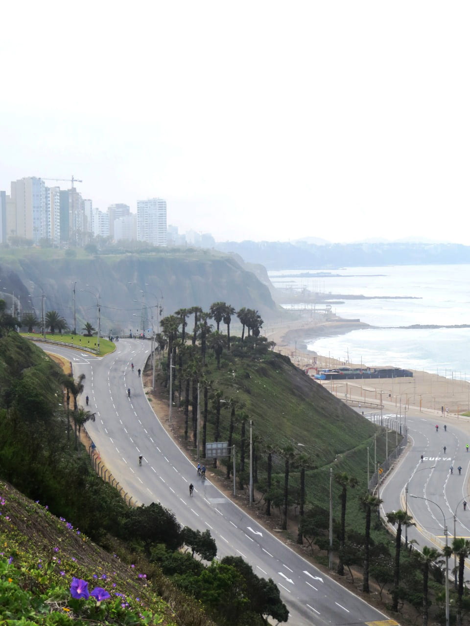
Costa Verde highway in Lima, during one of the car-free Sundays of 2020. Photograph by Wendy Leon.
This situation has been completely challenged since the beginning of the pandemic. Shortly after my arrival to Lima, the Covid-19 lockdown started. People could only go out of their houses to walk dogs or buy essentials on a strict schedule. During those months we experienced a completely shuttered and silent city. I was privileged enough to maintain my job and work from home during those months and to start my studies at Harvard remotely while the city reopened. Because of this, my life in the Peruvian capital was like one I would have never imagined: my neighborhood became my whole city and I only needed to walk around to get essential things.
As for many other people, my bicycle became an unexpected crucial and useful tool in my life, one that allowed me to commute greater distances avoiding the Covid-related risk of public transport. However, for many people who still needed to commute to their workplace from distant districts, using a bicycle was not a possibility because of the lack of a well-defined and safe bikeway network.
In this context, without even finalizing a proper urban bikeway plan, the Municipality of Lima started to implement low-cost and temporary bikeways in several of the city’s main arteries. Progressively, citizens started to experience an alternative way of moving through Lima reusing the existing road infrastructure and, by the end of 2020, the daily journeys done on bicycles in the city had doubled.

Costa Verde highway in Lima, during one of the car-free Sundays of 2020. Photograph by Kevin Malca.
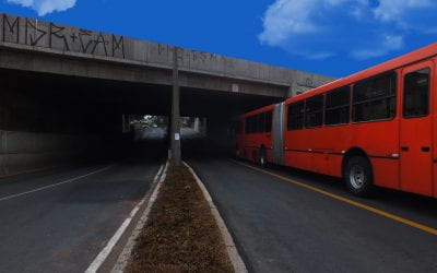
Even though that by July 2020, the national mandatory home quarantine had ended, some restrictions over the citizen’s mobility were maintained because of the spiraling rates of Covid-19. One of these restrictions started in September 2020, when the Municipality of Lima prohibited the use of motor vehicles on Sundays throughout the whole city. This didn’t affect my daily life but offered an alternative urban reality that we had never imagined before: a city of ten million people with 100% of its streets available for bikers and pedestrians. On those Sundays cycling across Costa Verde I encountered many friends who lived in distant districts that I hadn’t been able to see since before the pandemic started. An especially striking image for me was to see Costa Verde highway not only full of bikers but as a vibrant, easily accessible and not-polluted metropolitan gathering place in front of the Pacific Ocean.
Many of these temporary measures are nowadays being translated into long-term projects that seek to double the existing bikeway network and are being included in the metropolitan planning for the next decades. The aim in the short term is to improve the existing 141 miles of bikeways, expand and connect the existing network with almost 31 miles of “emergent” or temporal bikeways. In the long term, the goal is to reach a metropolitan network of 292 miles of bikeways. This will make Lima’s bike network one of the biggest of the continent, following in the path of Bogotá with its extensive 311 miles of bike paths and pedestrian thoroughfares. In the case of Lima, the State of Emergency context has accelerated the implementation of bikeways, avoiding the normal long bureaucratic processes. The experience has also influenced positively the perception of citizens regarding the use of more sustainable modes of transport.
In December 2020 I moved to Madrid, the city where I was born, and continued my second remote semester at Harvard from there, closer to my family. In contrast to Lima, Madrid has a very well-developed formal public transport system with one of the most extended subway networks in the world that, along with the bus system, covers the entire city.
Despite the excellent public transportation system, private vehicles accounted for 39% of trips within the city before the pandemic, while public transport represented only 24%. Journeys on foot fell in between at 34%. Beyond the center of the city, many more people relied on private vehicles: seven out of ten trips were made in cars, encouraged by the existing highway infrastructure and the poorer access to the public transport system in the outlying parts of the city. Meanwhile, as in Lima, in Madrid the use of bicycles represented less than 1% of the journeys within the city. The central area lacked a designated bikeway network, causing citizens to doubt the safety and reliability of this mode of transport.
After the general lockdown, the city of Madrid also implemented temporary and ambitious measures that encouraged the use of bicycles across the city by opening great avenues like Paseo de la Castellana and other local streets to pedestrian and bike traffic. The city council implemented 7.5 miles of temporary bikeways and created more than 50 new stations of the public bike system. However, most of these measures ended when the city gradually recovered its former levels of activity and, soon after the lockdown, the use of public transport fall to 9% and the percentage of journeys and cars increased to 60%. In Madrid, the covid-related risk of public transport and the high efficiency for commuting that the existing highway infrastructure offer for private vehicles has made the use of this transport mode the safest and preferred alternative for many residents of Madrid.
However, the reduction in the use of public transport was also translated in an increased number of people walking and using the bicycle, which represented in most of 2020 35% of the daily journeys. By July 2020 the use of the public bicycle system had grown 14% compared to the previous year. This switch in the mobility patterns positively influenced the local public urban policies. After what happened in 2020, the city council has recently approved a new Sustainable Mobility Ordinance that aims to encourage the use of alternative modes of transport by expanding the bikeway system, improving the public transport one with new bus lines, creating new pedestrian areas, and progressively limiting car-access to the city center to improve the air quality.
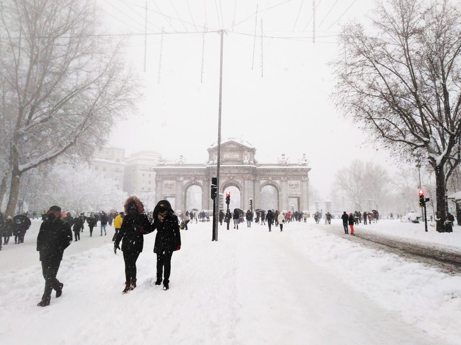
Alcala Street in Madrid during Filomena Storm in January 2021. Photograph by Juan Villalón.
In January 2021, while Madrid was recovering its normal levels of mobility, Filomena Storm hit the city and transformed in a different way, temporally but radically, the mobility patterns of the city. In my house, as in many others, we spent the hardest night of the snowfall without electricity. When we went out to the streets the next day, the city was unrecognizable. All the streets were covered by a thick layer of snow. Many trees had been tumbled or damaged, creating obstacles in the streets. The only way to move across the neighborhood was by walking slowly and carefully.
Later, we discovered that more than 70% of the historic trees had been lost and that all the hospitals, the rail stations, and even the airport were completely blocked. It was the heaviest snowfall in 50 years; the entire city was blocked for almost two days and didn’t fully recover for more than a week.
That first day, I managed to reach M30, the first highway that surrounds the city center. The image I saw is hard to forget: Instead of the infinite daily procession of cars and trucks, thousands of people were walking, playing, and even skiing down the highway. The normally forgotten inclined parks on the highway’s borders had been converted into improvised slopes where kids and adults were rolling down. There were snowmen in the middle of roundabouts and bridges and people were taking photos in formerly inaccessible places. The snow blurred the physical limits between the sidewalks and the roads and the city became literally a blank canvas that allowed pedestrians to temporally recover, reach and occupy the entire public space of Madrid. In this case, an extreme climate condition challenged the role of the existing infrastructure and was a reminder to both the local authorities and citizens that alternatives uses are possible and necessary.
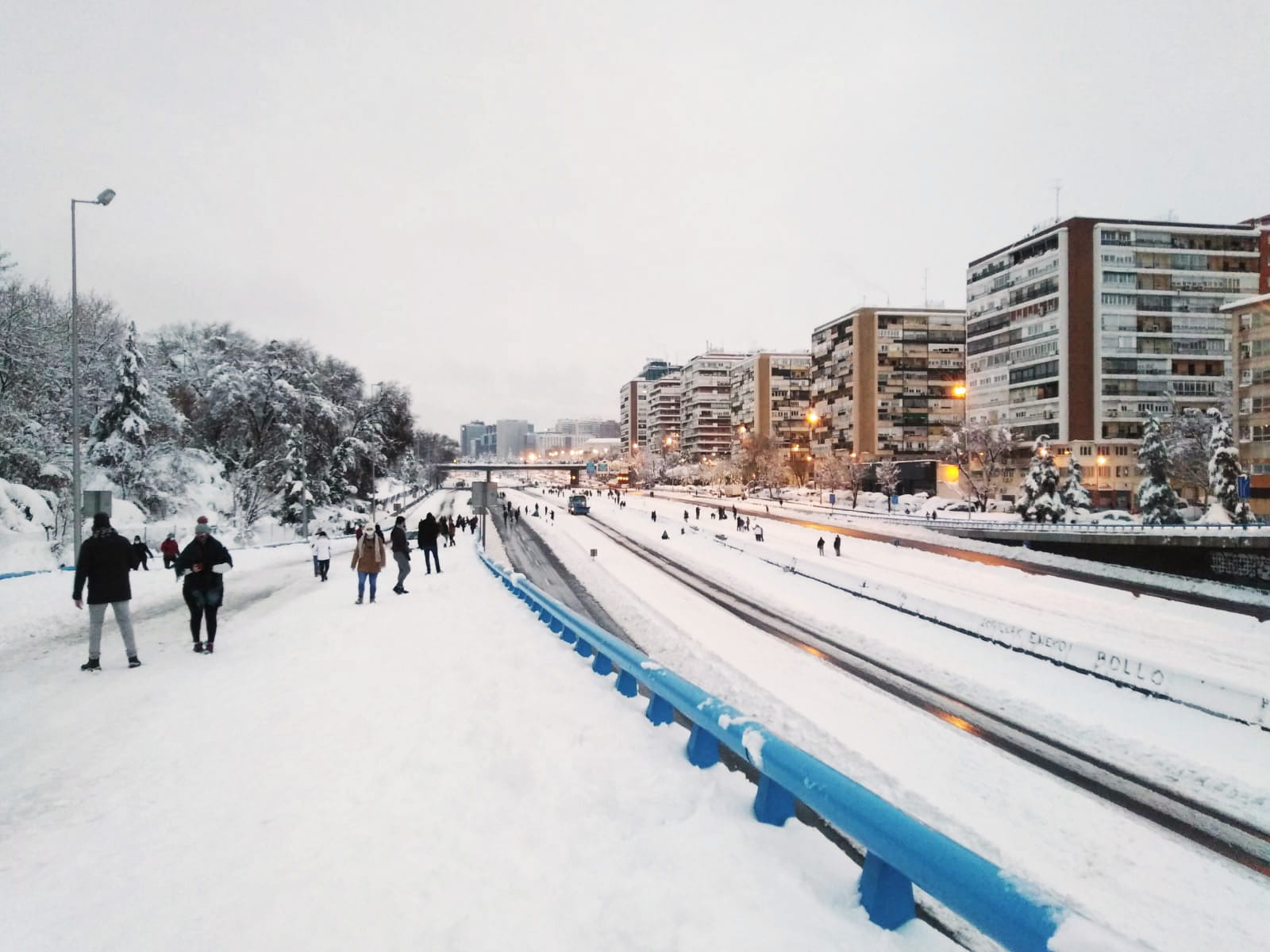
Madrid’s M30 highway during Filomena Storm in January 2021. Photograph by Juan Villalón.
These two experiences in Lima and Madrid show that urban crises—despite their difficulties —can be opportunities for change. The dual crises left important lessons for the future of our cities. First, temporary urban interventions have the power to reshape how we use our infrastructure in the long term. A critical context can create both political will and citizen consensus that allow decisions that could hardly happen in other situations, can accelerate implementation, and can influence metropolitan planning, as in the case of Lima’s bikeway network.
Second, our existing “permanent” infrastructure can be transformed into flexible frameworks for alternative urban uses. In this sense, new infrastructure is not always the solution, since we can reuse and transform what we have, even without physical adaptation, like what happened with Lima’s Costa Verde and Madrid’s M30 highways. These cases don’t prove that all our highways need to be for pedestrians but are effective demonstrations that showed both citizens and authorities the necessity and benefits of sharing our public spaces between different users and modes.
Finally, as contrasted with top-down urban planning that aims to predetermine what the city needs and how it must work, citizens, when offered the opportunity and the right context, have the potential and creativity to reuse the planned and formal city in unexpected ways, expanding the possibilities of our infrastructure. In this sense, developing short-term interventions engaged with long-term plans, adapting our existing infrastructure, and allowing citizens to test and participate in urban interventions can be powerful tools not only to deal with urban crises but to reimagine our cities beyond them.
Infraestructuras alternativas
Entre bicicletas y autopistas
PorJuan Villalón Hernando
El año pasado, experimenté dos formas diferentes en las que nuestro mundo antropocéntrico podría llegar a su fin. El primero fue la pandemia del Covid-19, cuando vivía en Lima y la forma en que la gente se desplazaba por la ciudad, lo que se conoce como los patrones de movilidad urbana, se transformaron.
El segundo fue en enero de 2021 en Madrid, España, cuando la tormenta Filomena arreció y bloqueó la capital española. Entre todas las dificultades y crisis humanitarias que ambos eventos causaron, descubrí que los usos inesperados y temporales de la infraestructura urbana existente, impulsados por ciudadanos, tienen el potencial de promover formas alternativas de planificar y diseñar nuestras ciudades.
En marzo de 2020 volví a vivir a Lima, la ciudad donde crecí, después de trabajar en Cusco durante dos años. Estaba emocionado a regresar a la vibrante capital peruana y reencontrarme con mis amigos y al mismo tiempo, algo asustado de volver a enfrentar los largos y diarios atascos de tráfico que caracterizan a la ciudad.
Con un incipiente sistema de transporte público formado por una línea de metro y otra de autobús de tránsito rápido (BRT) , la ciudad es mayormente servida por líneas de autobuses informales y de gestión privada que tienen un gran alcance, pero proveen una calidad de servicio muy deficiente. A pesar de esta situación, casi la mitad de todos los viajes en Lima son hechos en transporte publico, un cuarto de ellos se hacen a pie y solo uno de cada diez se realizan en vehículos privados (Lima Cómo Vamos, ¿Cómo vamos en Lima y Callao? Noveno informe de indicadores sobre Calidad de Vida, (Lima: Asociación UNACEM, 2019).
Sin embargo, durante décadas, la Municipalidad de Lima ha desarrollado proyectos de infraestructura que intentan resolver a corto plazo problemas de capacidad vial, pero que no tienen incidencia en la mejora del sistema de transporte publico y que fomentan el uso de vehículos privados. En este contexto, el número de coches y camiones crece todos los años y saturan el sistema de calles todos los días. Mientras tanto, las bicicletas son los vehículos que mayor cantidad de hogares posee, pero que , antes de la pandemia, representaban menos del 1% del total de viajes.
Carretera Costa Verde en Lima, durante uno de los domingos sin automóviles de 2020. Fotografía por Wendy Leon.
Esta situación empezó a cambiar desde el inicio de la pandemia. Poco después de mi llegada a Lima, el confinamiento obligatorio impuesto por el Covid-19 comenzó. Las personas solo podían salir de sus casas para pasear a sus mascotas o comprar lo esencial en un horario estricto. En este contexto, todos experimentamos una ciudad completamente cerrada y silenciosa. Yo tuve el privilegio de mantener mi trabajo desde casa durante esos meses y comenzar mis estudios en Harvard de forma remota mientras la ciudad reabría. Por eso, mi vida en la capital peruana fue como una que nunca hubiera imaginado: mi barrio se convirtió en toda mi ciudad y solo necesitaba caminar para llegar a lugares esenciales.
Como para muchas otras personas, mi bicicleta se convirtió en una herramienta inesperadamente crucial y útil en mi vida, que me permitía viajar distancias mayores evitando el riesgo del Covid-19- relacionado al transporte público. Sin embargo, para muchas personas que necesitaban trasladarse a su lugar de trabajo desde distritos distantes, usar una bicicleta era no era una posibilidad debido a la falta de una red de ciclovías bien articulada y segura.
En este contexto, sin finalizar un plan detallado de movilidad urbana, la Municipalidad de Lima comenzó a implementar ciclovías de bajo costo y temporales en varias arterias de la ciudad. Progresivamente, la ciudadanía comenzó a experimentar una forma alternativa de transitar por Lima reutilizando la infraestructura vial existente y, a finales de 2020, los recorridos diarios que se realizaban en bicicleta por la ciudad se habían duplicado.
Autopista Costa Verde en Lima, durante uno de los domingos sin automóviles de 2020. Fotografía por Kevin Malca.
Aunque que en Julio de 2020 el confinamiento domiciliario obligatorio había terminado, algunos restricciones sobre la movilidad ciudadana fueron mantendidas debido a las crecientes tasas de contagio de Covid-19. Una de estas restricciones empezó en septiembre 2020, cuando la Municipalidad de Lima prohibió el uso de vehículos a motor los domingos a lo largo de toda la ciudad. Esto no afectó mi vida diaria, pero ofreció una realidad urbana alternativa que nunca antes habíamos imaginado: una ciudad de diez millones de habitantes con el 100% de sus calles disponibles para ciclistas y peatones. Durante aquellos domingos en bicicleta por la Costa Verde pude encontrarme con muchos amigos que vivían en distritos distantes y a los cuales no había visto desde antes de que comenzara la pandemia. Una imagen especialmente cautivante para mí fue ver la autopista Costa Verde no solo llena de ciclistas, sino convertida en un lugar vibrante y de fácil acceso, un lugar metropolitano de reunión y sin contaminación frente al Océano Pacífico.
Muchas de estas medidas temporales se están traduciendo hoy en día en Lima en proyectos a largo plazo que buscan duplicar la red de ciclovías existente y se están incorporando en la planificación metropolitana de las próximas décadas. El objetivo a corto plazo es mejorar y rehabilitar los 227 kilómetros de ciclovías, ampliar y conectar la red existente con casi 50 kilómetros de ciclovías “emergentes” o temporales, y, a largo plazo, implementar una red metropolitana de 470 kilómetros de ciclovías. Esto hará que la red de bicicletas de Lima se convierta en una de las más grandes del continente, siguiendo el camino de Bogotá con su extensa red de ciclovías de 500 kilómetros. En el caso de Lima, el contexto del estado de emergencia ha acelerado la implementación de este tipo de infraestructura, evitando los largos procesos burocráticos normales. Además, esta crisis ha influido positivamente en la percepción de los ciudadanos sobre el uso de modos de transporte más sostenibles.
En diciembre de 2020 me mudé a Madrid, la ciudad donde nací, y desde allí continué mi segundo semestre remoto en Harvard, más cerca de mi familia. A diferencia de Lima, Madrid tiene un sistema de transporte público formal muy desarrollado con una de las redes de metro más extensas del mundo que, junto con el sistema de bus, abastece la totalidad de la ciudad.
A pesar del excelente sistema de transporte público, los desplazamientos en vehículo privado representaron el 39% de viajes dentro la ciudad antes de la pandemia, mientras que el transporte público representó solo el 24%. Mientras tanto, los viajes a pie representaban un 34% de los mismo. En el extrarradio madrileño, muchas más personas dependían uso del vehículo privado: siete de cada diez viajes eran hechos en coches, alentados por la infraestructura vial existente y el acceso más deficiente al sistema de transporte público en las zonas periféricas de la ciudad. Mientras tanto, al igual que en Lima, en Madrid el uso de la bicicleta representaba menos del 1% de los desplazamientosdentro la ciudad. El área central carecía de una red de ciclovías adecuadamente articulada, provocando que los ciudadanos dudaran de la seguridad y confiabilidad deeste modo de transporte.
Tras el cierre generalizado, la ciudad de Madrid también implementó medidas temporales y ambiciosas que alentaron el uso de bicicletas en toda la ciudad, abriendo grandes avenidas como el Paseo de la Castellana y otras calles locales al tráfico de peatones y bicicletas. El ayuntamiento implementó 12 km de ciclovías temporales y más de 50 nuevas estaciones del sistema de bicicletas público BiciMAD. Sin embargo, la mayoría de estas medidas terminaron cuando la ciudad recuperó gradualmente sus anteriores niveles de actividad y, poco después del confinamiento obligatorio, el uso del transporte cayó al 9% y el porcentaje de viajes en coche aumentó al 60%. En Madrid, el riesgo asociado al covid del transporte público y la alta eficiencia que ofrece la infraestructura vial existente para los vehículos privados ha hecho del uso de este modo de transporte la alternativa preferida para muchos madrileños.
Sin embargo, esta reducción del uso del transporte público se ha traducido también en un mayor número de personas caminando y usando la bicicleta, modos que conjuntamente han representado en la mayor parte del 2020 el 35% de los desplazamientos diarios. En julio de 2020 el uso del sistema de bicicletas públicas había crecido un 14% en comparación con el año anterior. Estos cambios en los patrones de movilidad han influido positivamente en las políticas urbanas locales. Tras lo acontecido durante el 2020, el ayuntamiento ha aprobado reciente mente una nueva Ordenanza de Movilidad Sostenible que tiene como objetivo fomentar el uso de modos de transporte alternativos, expandir el sistema de ciclovías, mejorar el transporte público creando nuevas líneas de bus no contminantes, crear nuevas zonas peatonales, y limitar progresivamente el acceso en coche al centro de la ciudad para mejorar la calidad del aire.
Calle Alcalá de Madrid durante la tormenta Filomena en enero de 2021. Fotografíade Juan Villalón.
En enero de 2021, mientras Madrid recuperaba sus niveles habituales de movilidad, la tormenta Filomena golpeó la ciudad y transformó de manera distinta, temporal pero radicalmente, los patrones de movilidad de la ciudad. En mi casa, como en muchas otras, pasamos la noche mas dura de la nevada sin luz. Cuándo salimos a la calle al día siguiente, la ciudad estaba irreconocible. Todas las calles estaban cubiertas por una gruesa capa de nieve.. Muchos árboles se había caído o dañado, creando obstáculos para transitar. La única forma de moverse por el vecindario era caminando lenta y cuidadosamente.
Más tarde, descubrimos que más del 70% de los árboles históricos de la ciudad se habían perdido y que todos los hospitales, las estaciones de tren, e incluso el aeropuerto estaba completamente bloqueados. Fue la nevada más intensa en 50 años: toda la ciudad estuvo bloqueada durante casi dos días y no se recuperó por completo durante más de una semana.
Ese primer día logré llegar a la M30, la primera autopista que rodea el centro de la ciudad. La imagen que vi es difícil de olvidar: en lugar de la infinita procesión diaria de automóviles y camiones, miles de personas caminaban, jugaban, e incluso esquiaban en la autopista. Los parques inclinados normalmente olvidados en los límites de la M30 se habían convertido en pistas improvisadas donde niños y adultos rodaban. Había muñecos de nieve en medio de rotondas y puentes y la gente estaba tomando fotos en lugares inaccesibles anteriormente. En Madrid, la nieve desdibujó los límites físicos entre las aceras y la calzada y la ciudad se convirtió literalmente en un lienzo en blanco que permitió a los peatones recuperar, alcanzar y ocupar temporalmente la totalidad del espacio público. En este caso, una condición climática extrema desafió el papel tradicional de la infraestructura existente y fue un recordatorio tanto para las autoridades locales como para los ciudadanos de que usos alternativos son posibles y necesarios.
Autopista M30 de Madrid durante la tormenta Filomena en enero de 2021. Fotografía de Juan Villalón.
Estas dos experiencias vividas en Lima y Madrid muestran que las crisis urbanas -a pesar de las grandes dificultades que general- pueden ser oportunidades de cambio y dejan lecciones importantes para el futuro de nuestras ciudades. Primero, las intervenciones urbanas temporales tienen el poder de transformar la forma en que usamos nuestra infraestructura a largo plazo. Un contexto crítico puede crear tanto la voluntad política como el consenso ciudadano para permitir decisiones que difícilmente podrían ocurrir en otras situaciones, puede acelerar los procesos de implementación e influir en la planificación metropolitana, como el caso de la red de ciclovías de Lima.
En segundo lugar, nuestra infraestructura “permanente” existente puede convertirse en escenarios flexibles para usos urbanos alternativos. En este sentido, construir nueva infraestructura desde cero no siempre es la solución, ya que podemos reutilizar y transformar lo que tenemos, incluso sin grandes adaptaciones, como sucedió con las autopistas Costa Verde de Lima y la M30 de Madrid. Estos casos no prueban que todas nuestras carreteras deban ser para peatones, pero sí son recordatorios efectivos que demuestran tanto a los ciudadanos como a las autoridades la necesidad y los beneficios de compartir nuestros espacios públicos entre diferentes usuarios y modos de transporte.
Finalmente, en contraste con la planificación urbana de arriba hacia abajo que tiene como objetivo predeterminar qué necesita la ciudad y cómo debe funcionar, los ciudadanos, cuando se les ofrece la oportunidad y el contexto adecuado, tienen el potencial y la creatividad para reutilizar la ciudad planificada y formal de formas inesperadas y expandir las posibilidades denuestra infraestructura. En este sentido, desarrollar intervenciones a corto plazo comprometidas con planes a largo plazo, adaptar nuestra infraestructura existente y permitir que los ciudadanos prueben y participen en las intervenciones urbanas pueden ser herramientas efectivas no solo para hacer frente a las crisis urbanas, sino para reimaginar nuestras ciudades más allá de ellas.
Fall 2021, Volume XXI, Number 1
Juan Villalón Hernando is an architect and a Master in Urban Design candidate at the Harvard Graduate School of Design. He was born in Madrid and grew up in Lima and has worked in several urban projects involving public space design, landscape resilience, and sustainable mobility. At Harvard, he is part of the leading team of the Climate Leaders Program for Professional Studies and is interested in the intersection of climate change, urbanization, and infrastructure.
Juan Villalón Hernando es arquitecto y candidato al Máster en Diseño Urbano en la Escuela de Diseño de Harvard. Nació en Madrid y creció en Lima y ha trabajado en varios proyectos urbanos que involucraron el diseño de espacios públicos, la resilencia del paisaje, y la movilidad sostenible. En Harvard, es parte del equipo organizador del Programa de Líderes Climáticos para Estudiantes Profesionales y está interesado en la intersección entre el cambio climático, la urbanización y la infraestructura.
Related Articles

La Güera Rodríguez
By now, history has added a layer to the many ironies that Brandeis historian Silvia Arrom highlights in her spirited book about a controversial historical figure. The recent irony is…
Authoritarian Police in Democracy
This deeply researched book suggests to its reader a truly tragic paradox: the possibility that under certain conditions, democratic institutions and processes may undermine rather than strengthen the rule of law. Building on grounded…
Improving Public Transport
The voices of young males yelling the destination of their combis woke me up early every morning while I lived in La Paz (Bolivia) for a couple of months in the mid-1990s. I did not need an alarm clock. These people yelled in loud voices to inform prospective passengers…
